


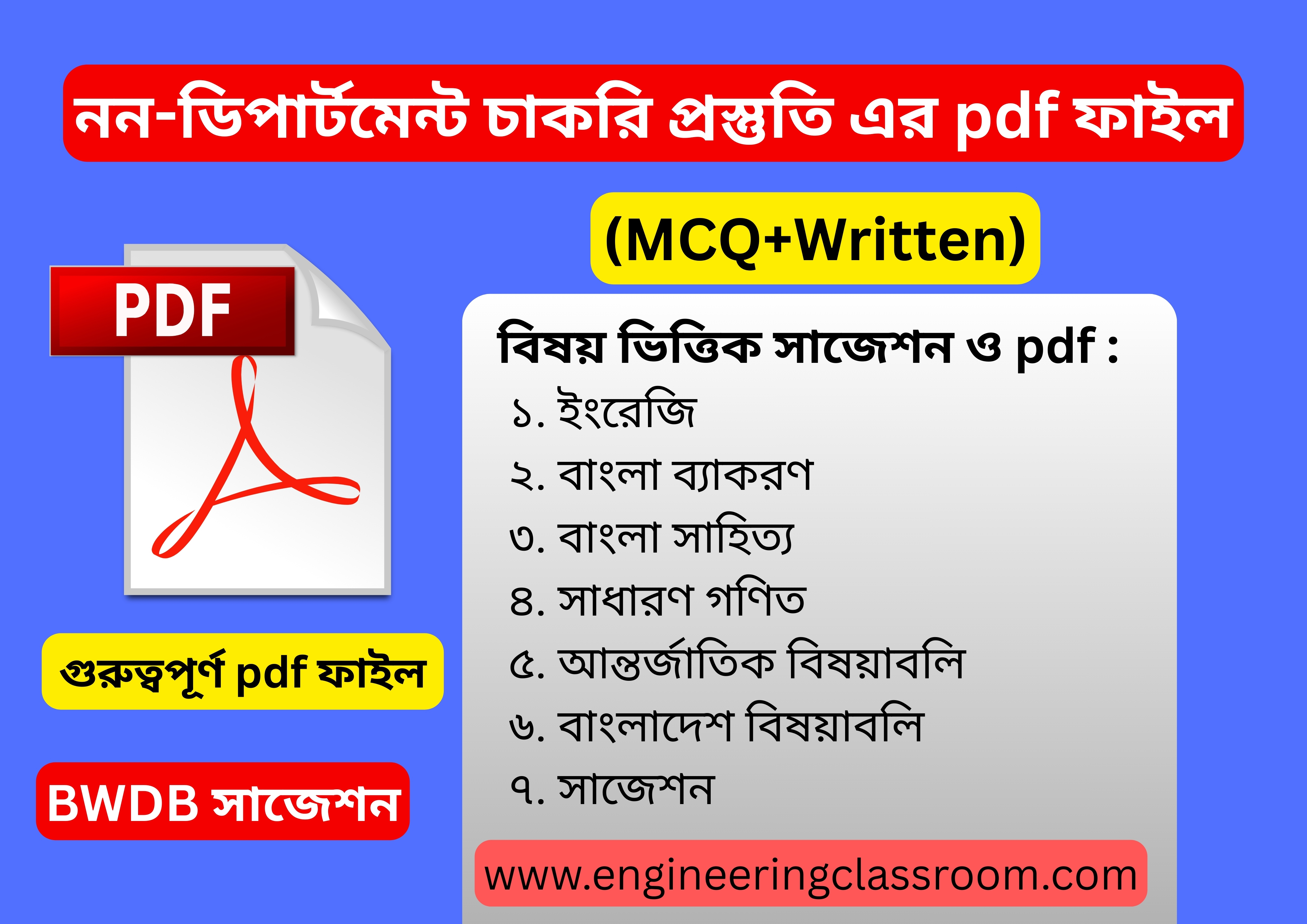
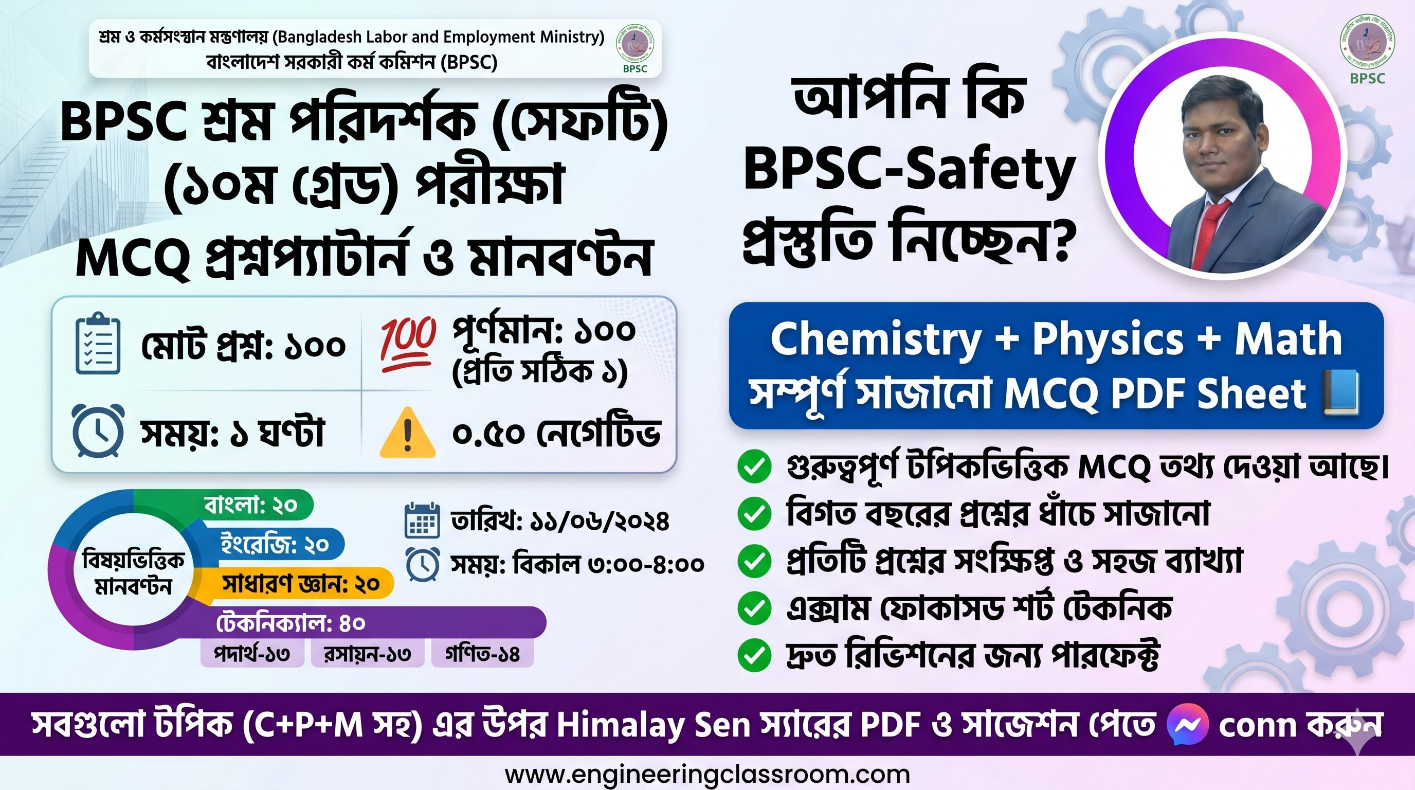
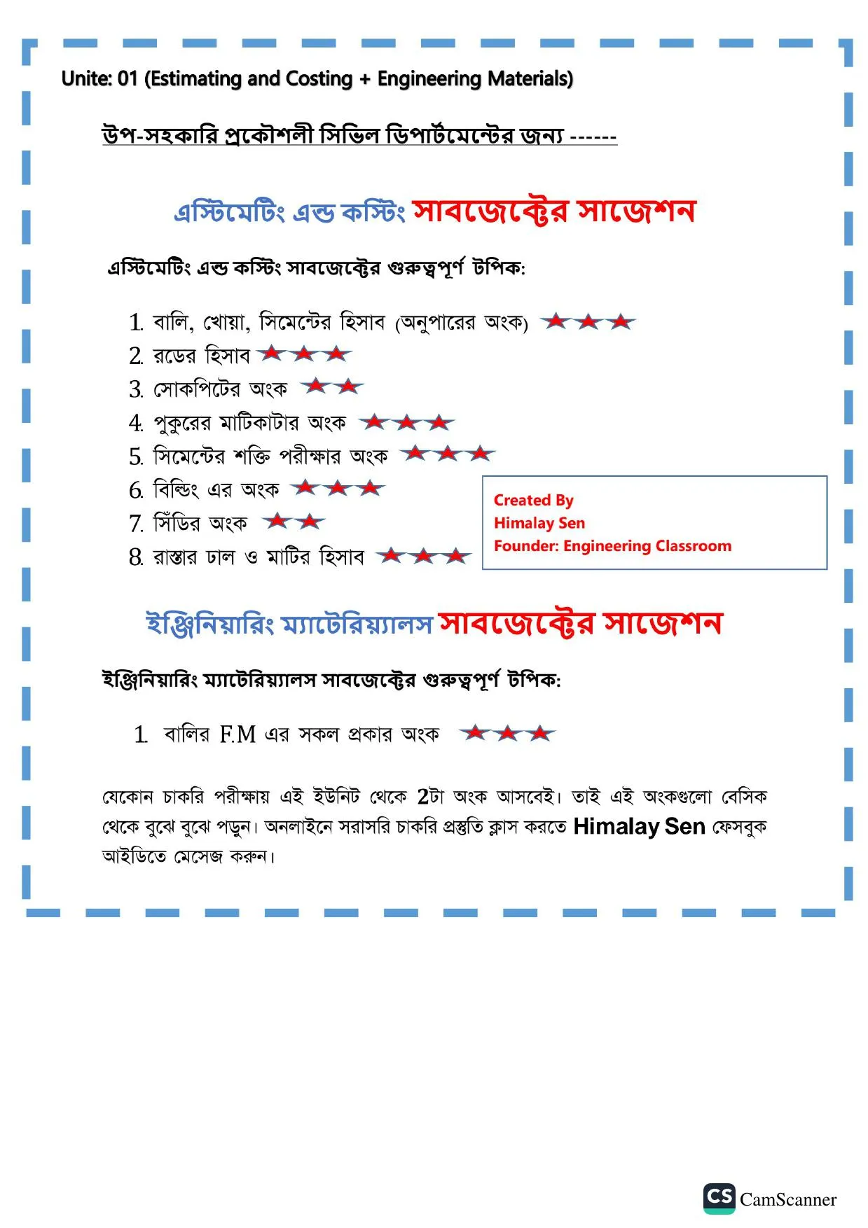

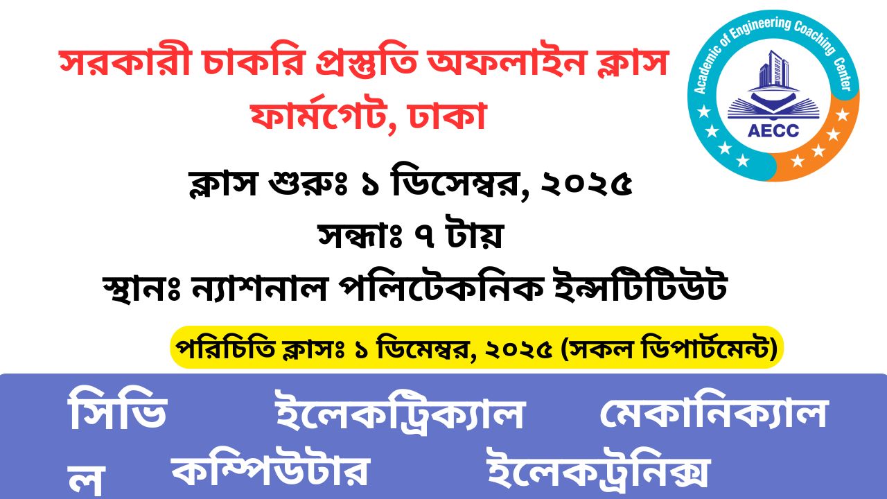


সার্ভেয়িং MCQ
সিভিল ডিপার্টমেন্টের "" সার্ভেয়িং "" সাবজেক্টের সকল MCQ এখানে পাবেন। Civil Engineering এর চাকরি প্রস্তুতির জন্য ডিপার্টমেন্ট ও নন-ডিপার্টমেন্টের সকল MCQ এর প্রশ্ন উত্তর ব্যাখ্যাসহ এখানে পাবেন। সহকারী/উপ-সহকারী প্রকৌশলী চাকরি প্রস্তুতির জন্য আমাদের App: Engineering Classroom গুগল প্লে-স্টোর থেকে ডাউনলোড করে নিন। Surveying all MCQ, Civil Engineering MCQ
1. কোন Survey method Field observation এ Plotting একই সাথে করা হয়?
Plane Table Survey
Chain Survey
Tacheometry Survey
Compass Survey
ব্যাখ্যা: Explainedঃ প্লেন টেবিল জরিপ একটি লৈখিক জরিপ। প্লেন টেবিল জরিপে মাঠ পরীক্ষা এবং নকশায়ন একই সাথে করা হয়। জরিপকর মাঠে সরাসরি নকশায় অঙ্কিত তথ্যাদি যাচাই করে নিতে পারে। উত্তর সহ কয়েকটি অনুরুপ গুরুত্বপূর্ণ প্রশ্ন 1. কোন Survey metod Field observation এবং Plotting একই সাথে করা হয় Plane Table Survey 2. কৌণিক ও দৈর্ঘ্য পরিমাণ করা হয় না কোন জরিপ এ- plain table survey. 3. কোন জরিপ এ জরিপ লিপি প্রয়োজন নেই- Plain table survey. 4. সমান্তরাল ও সমানুপাতিক নীতির উপর প্রতিষ্ঠিত কোন survey Plain table survey. 5. আর্দ্র আবহাওয়ায় কোন জরিপ করা যায় না. Plain table survey. 6. Plain table survey এ table এর আকার- 600 mm x750 mm.
2. 347° এর Reduced Bearing--
13° EN
13°NW
77°SE
77° SW
ব্যাখ্যা: উত্তর সহ কয়েকটি অনুরুপ গুরুত্বপূর্ণ প্রশ্ন 1. 347° এর Reduced Bearing - 13° NW 2. কোনো রেখা মধ্য রেখা হতে ভানাবর্তে যে অনুভূমিক কোণ উৎপন্ন করে তাকে বলে-- Bearing. 3. 30° NE. এর পূর্ণবৃত্ত বিয়াকিং -40° 4. 3° NW at Whole circle bearing-357° 5. 210° এর হ্রাসকৃত বিয়ারিং কত- 30° SW.
3. Chain survey is most appropriate for-Mes-
Small place
Plain and open place
When plain needed for a large scale
All of above
ব্যাখ্যা: উত্তর সহ কয়েকটি অনুরুপ গুরুত্বপূর্ণ প্রশ্ন। 1. Check lines (or proof lines) in Chain Surveying. are essentially required - To indicate the accuracy of the survey work-To increase the cut-an 2. Chain surveying is well adopted for-Small areas in open ground 3. In chain surveying field work is limited to – Linear measurements only 4. Prolongation of chain line across an obstruction in chain surveying, is done - Drawing perpendiculars with achain 5. In chain surveying, perpendiculars to the chain line are set out by-An optical square
4. একটি Contour ম্যাপের কেন্দ্রের দিকে উচ্চতা বাড়লে বুঝা যায়, এটি-
জলাশয়
পাহাড়
সমতলভূমি
উপরের কোনোটিই নয়
ব্যাখ্যা: উত্তর সহ কয়েকটি অনুরুপ গুরুত্বপূর্ণ প্রশ্ন ১। সমদূরত্বে কন্ট্রর রেখার অবস্থিতি নির্দেশ করে –সমঢাল ২। কন্টুর মানচিত্রের ক্ষেত্রে কোনটি সভা? মানচিত্র মাঝখানে শেষ হবে না। এটি মিলে যাবে, মানচিত্রের বাইর দিকে চলে যাবে ৩। ধারাবাহিক বন্ধ কন্টুর রেখাগুলোর যদি বাইরের দিকে কন্টুর মান যেশি হয়, তবে তা নির্দেশ করে- জলাশয় বা পুকুর ৪। কন্টুর রেখা উপত্যকা বা অধিকাতা রেখাকে ছেদ করে -সমকোণে ৫। ভূসংস্থানিক মানচিত্রের সাথে সাদৃশ্য- কন্টুর মানচিত্র
5. শুধুমাত্র একটি সেট স্কয়ার দিয়ে কোন কোণটি অঙ্কন করা যায় না?
30°
45°
60°
75°
ব্যাখ্যা: Explained: সেট অয়ার বলতে দুটি ত্রিভুজ জাতীয় বস্তু বুঝায়, যার একটির কোণ 30°, 60° ,90° এবং অন্যটির মান 45°, 45° ও 90° হয়ে থাকে।
উত্তর সহ কয়েকটি অনুরুপ গুরুত্বপূর্ণ প্রশ্ন
1. শুধুমাত্র একটি সেট স্কয়ার নিয়ে কোণ কোনটি অঙ্কন করা যায় না-৭৫° 2. Set square এর সাহায্যে কোন কোন মাপা যায়-30°, 60° , 45° 3.লম্ব বারবিশিষ্ট Set square কীসের সাহায্যে অংকন করা হয়- Pencil
6. নিচের কোনটি Modern Survey Instrument নয়?
EDM
Total Station
Digital Level
Plain Table
ব্যাখ্যা: Explained:- EDM এর পূর্ণরূপ Electronic Distance Measurement Plain Table, Modern Survey Instrument নয়।
উত্তর সহ কয়েকটি অনুরুপ গুরুত্বপূর্ণ প্রশ্ন
1. নিচের কোনটি Modern survey instrument নয়-Plain Table. 2 কোনটি Modern survey instrument - Theodolite. Total Station, RTK, GPS etc. ৭. কোনটি শুধু কোণ পরিমাপক survey instrument-Theodolite, 4. কোন Digital Survey instrument এর সাহায্যে Angle, Distance, Area ইত্যাদি নির্ণয় করা হয়- Total Station.
7. A ও B দুই বিন্দুর দূরত্ব =50 মিটার, উচ্চতার পার্থক্য-1 মিটার। Gradient=?
2%
20%
5%
কোনোটির নয়
ব্যাখ্যা: Explained: প্রতি 50 মিটার দূরত্বে উচ্চতা 1 মিটার হলে ঢাল হবে 1×100/ 50 =2%.
উত্তর সহ কয়েকটি অনুরুপ গুরুত্বপূর্ণ প্রশ্ন
1. A ও B দুই বিন্দুর দূরত্ব =50m, উচ্চতার পার্থক্য =1m Gradient-2%
2. সমকোণী ত্রিভুজের ভূমি-50cm কোণ=45° হলে উচ্চতা কত -45cm
3. একটি ঢালু ভূমি অনুভূমিকের সাথে ১০° উৎপন্ন করে, ভূমিটির ঢাল কত-0.58.
4. ঢাল Negative হলে ভূমি কোন দিকে হেলানো থাকে- নিচের দিকে।
8. লেভেল যন্ত্রের সমন্বয় কত প্রকার?
2 প্রকার
3 প্রকার
4 প্রকার
5 প্রকার
9. A এবং B স্থানের Staff Reading যথাক্রমে 5.75 , 6.85 মিটার। A স্থানের R.L যদি 200 মি. হয়, তবে B স্থানের R.L--
194.25 মি
198.9 মি
201.১ মি
206.86 মি
ব্যাখ্যা: উত্তর সহ কয়েকটি অনুরুপ গুরুত্বপূর্ণ প্রশ্ন 1. A এবং B স্থানের Staff Reading যথাক্রমে 5.75, 6.85m .Α স্থানের R.L. যদি 200 m হয়, তবে B স্থানের R.L কত- 194.9m) 2. C বিন্দুতে যন্ত্র বসিয়ে A ও B বিন্দুর স্টাফ পাঠ পাওয়া গেল যথাক্রমে 1.605 m এবং 1.505 m. A বিন্দুর RL-54m হলে, B বিন্দুর RL. কত- 54.1 m. 3. A , C বিন্দুর স্টাফ পাঠ যথাক্রমে 5.82m , 6.47m ,, . A বিন্দুর RL 100m,, . B বিন্দুর RL 98.18m . . C বিন্দুর RL কত-99.35m
10. একটি কক্ষের মেঝে ও ছাদের তলদেশে Staff reading যথাক্রমে 0.905m-3.04m, কক্ষের উচ্চতা কত?
3.985m
2.095m
3.04m
3.513m
ব্যাখ্যা: Explained: কক্ষের উচ্চতা= মেঝের স্টাফ পাঠ+ ছাদের তলার স্টাফ পাঠ = 0.995+3.04 (মানে স্টাফ উল্টাভাবে ধরা) কক্ষের উচ্চতা= 4.035m উত্তর সহ কয়েকটি অনুরুপ গুরুত্বপূর্ণ প্রশ্ন 1. একটি কক্ষের মেয়ে ও ছাদের তলদেশে স্টাফ রিডিং 0.995 m 3.04 m। কক্ষের উচ্চতা কত- 4.035. 2. মেঝের B1-25 m. স্টাফ স্বাভাবিক অবস্থায় মেঝেতে প্রাপ্ত স্টাফ পাঠ 1.705 m এবং ছাদের তলায় স্টাফ উল্টা অবস্থায় ধরে প্রাপ্ত স্টাফ পাঠ 3.945 m. কক্ষের উচ্চতা কত-5.65m 3. একটি কক্ষের মেঝে এবং ছাদের তলার RL যথাক্রমে 1.2m এবং- 2.60 m. কক্ষের উচ্চতা কত-3.8m 4. কক্ষের মেঝে, ছাদের তলদেশ ও বিমের তলদেশে প্রাপ্ত স্টাফ পাঠ যথাক্রমে 0.945 m. -1.04m-2.54 m। বিমের গভীরতা কত-0.5 m.
11. যদি A ও B বিন্দুর level পার্থক্য 1m হয় এবং তাদের দূরত্ব 50m হয় তাহলে gradient --
1 in 2
50%
2%
1 in 50
12. One hectare of land equal to -(এক হেক্টর জমির সমান-)-
2.417 acre
2.471 acre
2.517 acre
2.571 acre
ব্যাখ্যা: Explained: হেক্টর, ভূমি পরিমাণের একটি একক। পুরনো মেটিক পদ্ধতির অংশ কিন্তু আধুনিক মেট্রিকপদ্ধতিতে এটিকে রাখা হয়নি। ১ হেক্টর গহান = ১০০০০ m³ = ২.৪৭১ একক। উত্তর সহ কয়েকটি অনুরুপ গুরুত্বপূর্ণ প্রশ্ন 1. If total run off of a basin of 50 hectares is 0.8 cm, the ordinate of Bernard's distribution graph, may be calculated by the formula (where Q is the discharge in cumecs at the given time) - y = 250Q 2. An intense rain is falling at a uniform rate of 7.5 cm/hour for a period of 60 minutes on a basin whose area is 500 hectares. If the average infiltration capacity during the entire rain period is assumed to be 1.5 cm/hr, the maximum run-off rate based on 10 minute peak percentage of 16% from distributing graph of the basin, is - 80 3. If the optimum depth of kor watering for a crop is 15.12 cm, the outlet factor for the crop for four week period in hectares per cumec, is-1600
13. একটি drawing- এর দৈর্ঘ্য 50mm এবং sclae-1.:5 হলে এর সঠিক দৈর্ঘ্য কত?
25mm
25cm
10cm
10mm
ব্যাখ্যা: Explained: 50: x = 1:5
50/ X =1/5
X= 250 mm
= 25 cm
উত্তর সহ কয়েকটি অনুরুপ গুরুত্বপূর্ণ প্রশ্ন 1. একটি drawing এর দৈর্ঘ্য 50 mm এবং scale-1:5 হলে এর সঠিক দৈর্ঘ্য কত- 25 cm. 2. একটি drawing এর দৈর্ঘ্য 10 mm এবং scale 1:100 হলে এর সঠিক দৈর্ঘ্য কত -100cm. 3. একটি রেখার সঠিক দৈর্ঘ্য 100 m এবং scale-1:1000 হলে এর drawing দৈর্ঘ্য - 10 cm. Drawing এ একটা বর্গক্ষেত্রের ক্ষেত্রফল 100 cm^2 এবং scale-1:1000 হলে এর সঠিক ক্ষেত্রফল কত- 10000 m^2.
14. Engineering chain-এর দৈর্ঘ্য কত?
66 ft
100 ft
33 ft
50 ft
ব্যাখ্যা: Explained: (ক) গান্টার শিকল(৬৬ ফুট)। (খ) প্রকৌশল বা স্থাপতি শিকল (১০০ ফুট)। (গ) মিটার শিকল (২০-৩০ মিটার)। উত্তর সহ কয়েকটি অনুরুপ গুরুত্বপূর্ণ প্রশ্ন 1. 20 m chain এ সর্বোচ্চ tolerance কত- ± 5 mm 2. নিচের কোনটি মিটার শিকল -30 m chain. 3. নিচের কোনটি প্রকৌশল শিকল- 100 ft chain. 4. নিচের কোনটি গান্টার শিকল- 66 ft chain. 5. গান্টার শিকল ব্যবহার করা হয় সাধারণত- ভূমি পরিমাপে। 6. প্রকৌশল শিকলের মাপ প্রকাশ করা হয়- বর্গফুটে
15. নির্মূল Plane Table Survey- Centering বের করার জন্য যে যন্ত্র ব্যবহার কর হয়, তার নাম—
Spirit level
Alidade
Plumbing fork
Trough compass
ব্যাখ্যা: Explained- Plan table Surver-এর ক্ষেত্রে centering করার জন্য Plumbing fork ব্যবহার করা হয়ে থাকে। এটি একটি রশির মাথায আটকানো থাকে, যা একটি নির্দিষ্ট স্থানের centering করার জন্য ব্যাবহার। করা হয়, এটিকে Plumbing হয়। উত্তর সহ কয়েকটি অনুরুপ গুরুত্বপূর্ণ প্রশ্ন ১। কোন জরিপে একই সাথে মাঠের কাজ ও নকশায়ন সম্পন্ন হয়-প্লেন টেবিল জরিপ ২। এলনসহ ডিমটা যন্ত্রটি ব্যবহৃত হয়- প্লেন টেবিল জরিপ ৩। ছোট ছেলের নকশায়নে বিশেষ উপযোগী-প্লেন টেবিল জরিপ ৪। স্বল্প সময়ে সহজে ঘের দেওয়ার জন্য করা হয় -প্লেন টেবিল জরিপ
16. A fixed point of referenct of known elevation is called-
change point
statio pont
bench mark
datum Ang
ব্যাখ্যা: Explained. A relatively fixed point of known elevation above datum is called bench mark.
উত্তর সহ কয়েকটি অনুরুপ গুরুত্বপূর্ণ প্রশ্ন।
1.A relatively fixed point of known elevation above datum, is called mark 2. The power of a lensis measured in Dipter 3. The approximate formula for radial or perpendicular offsets from the tangent, is-x/28 4. The included angles of a theodolite traverse, are generally measured-Clockwise from the hack Mathion 5. The intercept of a staff-Is mirimum if the staff is hold truly normal to the line of sight 6. In a constant level tube, size of the bubble remains constant because upper wall is of relately larger radia
17. একটি ৫০ সারকুলার কার্ডের প্রতিসরণ কোন ২৫০, যদি চেইনেজ ২০০০ মিটারে কার্ড আরাম্ভ হয়, তবে অ্যাপেক্সেও চেইনেজ কত?
২০৭৫ মিটার
২০৯০ মিটার
২১০০ মিটার
২১৭৫ মিটার
18. Optical Square নিচের কোন Angles Measure এর জন্য ব্যবহার হয়?
Refraction
Reflection
Double Refraction
Double Reflection
ব্যাখ্যা: Explained: Optical Square সাধারনত Reflection এর জন্য ব্যবহার হয়।
উত্তর সহ কয়েকটি অনুরুপ গুরুত্বপূর্ণ প্রশ্ন।
1. Optical Square নিচের কোন Angeles measure এর জন্য ব্যবহার হয়- Reflection. 2. Optical square এর আয়নাদ্বয় পরস্পরের সাথে কত ডিগ্রি কোণে বসানো থাকে- 45°. 3. সূচক দৃষ্টি ও দিক চক্রবাল দৃষ্টির মধ্যবর্তী কোণের মান কত- 90°. 4. কোনো নির্দিষ্ট বিন্দু হতে শিকল রেখার উপর লম্ব পদমূল চিহ্নিত করণের জন্য কোনটি ব্যবহার করা হয় – Optical Square. 5. শিকল রেখার কোনো বিন্দুতে লম্ব স্থাপনের জন্য কোনটি ব্যবহার করা হয় -Optical Square. 6. কোনো আলোকরশ্মি দুটি প্রতিফলক এর উপর পর্যায়ক্রমে প্রতিফলিত হলে এদের অন্তর্ভুক্ত কোণ প্রতিফলকদ্বয়ের উপর অন্তর্ভুক্ত কোণের কত গুণ- দ্বিগুণ।
19. Engineer's Chain এর দৈর্ঘ্য কত?
66 ফুট
100 ফুট
৪০ ফুট
120 ফুট
ব্যাখ্যা: Explained : Enginner's chain- এর দৈর্ঘ্য 100ft Gunter's Chain - এর দৈর্ঘ্য 66ft Meter chain এর দৈর্ঘ্য 10m, 25, 30m. উত্তর সহ কয়েকটি অনুরুপ গুরুত্বপূর্ণ প্রশ্ন 1. Engineers Chain এর দৈর্ঘ্য কত- 100ft 2. Engineen Chan এর ক্ষেত্রফল কিসে প্রকাশ করা হয়- বর্গফুটে। 3. গান্টার শিকলের দৈর্ঘ্য- ৬৬ ফুট। 4. সান্টার শিকলের ক্ষেত্রফল কিসে প্রকাশ করা হয়-একরে। 5. সাধারণত তুমি পরিমাপে ব্যবহার করা হয়- গান্টার শিকল।
20. একটি Plain scale ব্যবহার হয় ?
One Dimension
Two Dimension
Three Dimension
Any of them
ব্যাখ্যা: Explained: Plain scale ব্যবহার হয় শুধু tow diamension axis এ যার দুটি Axis থাকে X-X & Y-Y Axis. উত্তর সহ কয়েকটি অনুরুপ গুরুত্বপূর্ণ প্রশ্ন।
1. একটি Plain Scale ব্যবহার হয় to read - two dimension. 2. Line কোন Dimension এ পরিমাপ করা হয়-One Dimension. 3. Area কোন Dimension এ পরিমাণ করা হয় -Two dimension. 4. Volume কোন Dimension এ পরিমাপ করা হয় -Three Dimension.